
Conservation and Recreation Opportunities
Fairhaven is home to a variety of places where you can explore the outdoors, whether its field, forest, or marsh. Fairhaven hosts just a small portion of the opportunities across the Buzzards Bay region. The Buzzards Bay Coalition provides a list of all of these places to go in the Buzzards Bay watershed. Find one that looks interesting and start exploring!
Places to Go in Fairhaven
Carvalho Farm
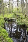
Carvalho Farm offers a variety of natural beauty to explore in a short amount of time. The Indian Rock Trail (download the Carvalho Farm trail map) takes you through former farmland now maintained as a natural meadow, forest, along a stream, and over wetlands. The end of the trail offers scenic vews of marshes to your east and west. More information on Carvalho Farm from Buzzards Bay Coalition.
Fairhaven TV Hometown Hikes - Carvalho Farm Trail for a look at what you might see on the trail!
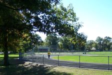 Located just north of Town Center, Cushman Park is a flat, grassy park with Baseball fields, running track, amphitheatre, playground equipment and tennis courts. Facilities include restrooms and a concession stand. There is limited public parking at the park. There is a paved path that winds through the park.
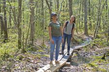
East Fairhaven School Trail
The East Fairhaven School Trail (download the East Fairhaven School trail map) offers abundent opportunity to learn about nature in your own backyard with boardwalks and tree stump paths across streams and wetlands. The trail is open to the public outside of school hours (weekdays 8:00am-3:00pm) and connects with another footpath through neighboring Nasketucket Woods. More information on the East Fairhaven School Trail from Buzzards Bay Coalition.
Fairhaven TV Hometown Hikes - East Fairhaven School Trail for a look at what you might see on the trail!
Edgewater Street Kayak Launch
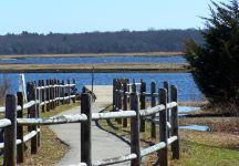
Access the waters of Nasketucket Bay and explore the surrponding salt marshes from the Edgewater Street Kayak launch. Use caution if you're launching at low tide, the launch is rocky and shallow. Also be aware that the street can flood at high tide. You can find more information on the Egdewater Street Kayak Launch from Buzzards Bay Coalition or contact the Fairhaven Harbormaster (harbormaster@fairhaven-ma.gov, (508) 979-4023 ext 124).
Egypt Lane
The Hurricane Barrier at Egypt Lane is a popular birdwatching spot and looks out over salt marshes and the shoreline of New Bedford Harbor. Stop to take in the view while enjoying the Phoenix Bike Trail. Please respect homeowners’ privacy and do not continue past the dike; the road beyond the dike is private. More information on Egypt Lane from Buzzards Bay Coalition.
Fort Phoenix and Fort Phoenix State Reservation
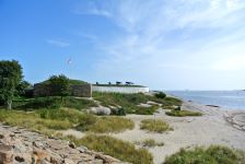 Fort Phoenix (1775-1876) was built between 1775 and 1777 and was outfitted with eleven cannons, one of which can be seen there today. The fort was attacked and destroyed by the British in 1778 and rebuilt following that attack, when it was named Fort Phoenix. The fort was manned through the Civil War and went out of service in 1876. You can explore the historic fort and enjoy a picnic in the park nearby. Fort Phoenix State Reservation offers a beach and park with spectacular views of New Bedford Harbor, Buzzards Bay, Butler Flats Lighthouse, and the Elizabeth Islands.
You can find more information on the Fort from the Fairhaven Office of Tourism and more information on the State Reservation from Buzzards Bay Coalition.
Hoppy's Landing
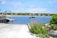
Hoppy's Landing by the West Island causeway offers a boat ramp and pier for boaters to launch from and a small, sandy beach for paddlers to launch from. You can also explore the beach and salt marsh here. You can find more information on Hoppy's Landing from Buzzards Bay Coalition or contact the Fairhaven Harbormaster (harbormaster@fairhaven-ma.gov, (508) 979-4023 ext 124).
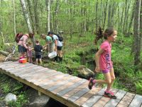
LeRoy L. Wood School Trail
The Wood School Trail (download Wood School trail map) is a great way to explore coastal woods and wetlands. Blue blazes mark the trail and you'll find small boardwalks over the wettest areas to keep your feet dry. There is a vernal pool, a seasonal pool of water that provides habitat for some species of frogs and salamanders, about halfway along the trail. The trail is open to the public outside of school hours (weekdays 8:00am-3:00pm) and ends at the salt marsh and a scenic overlook of Priests Cove. More information on the Wood School Trail from Buzzards Bay Coalition.
Fairhaven TV Hometown Hikes - Wood School Trail for a look at what you might see on the trail!
Little Bay Conservation Area
You can explore Little Bay Conservation Area by foot, boat, or bike. The Little Bay Extension from the Phoenix Bike Trail (download Phoenix Bike trail map) takes you through the conservation area to a small concrete pier, where you can take in an incredible view of Little Bay and Nasketucket Bay. There is also a small network of unpaved trails that loop through the woods. Little Bay Conservation Area is also popular in the spring for fishing. More information on Little Bay Conservation Area from Buzzards Bay Coalition.
Livesey Park
 Livesey Park, located at Glenhaven Avenue and Livesey Parkway, is a relatively flat, grassy park with two tennis courts, three baseball fields, football practice area, a basketball court and play equipment. Facilities include a changing room and/or restroom. This site is located adjacent to the Oxford School. There is currently no off street parking available at this park. There is a paved path that winds through the park.
Macomber & Pimental Park
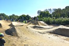 Macomber & Pimentel Park, located on Bernese Street, consists of a ballfield, an adjacent open field with play equipment, and a BMX bicycle pump track. A twenty-car unpaved parking area is provided adjacent to the ballfield. There is also a playground with swings, slide, monkey bars, and seesaw.
Photo by Beth David
New Boston Trail
The New Boston Trail (download New Boston trail map) is part of the Mattapoisett River Reserve. You can explore its forest and wetland habitats and, if you're looking for a longer walk, you can continue on to The Bogs or Tripps Mill and the Tinkhamtown Woodlands. You can find more information on the New Boston Trail from Buzzards Bay Coalition.
Fairhaven TV Hometown Hikes - New Boston Trail for a look at what you might see on the trail!
Pease Park
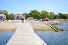
The Jim Holmes Memorial Boat Ramp at Pease Park offers access to inner New Bedford Harbor and Buzzards Bay for boats up to 50 feet long. There is trailer parking for a small daily fee and dinghy storage. You can find more information on Pease Park from Buzzards Bay Coalition or contact the Fairhaven Harbormaster (harbormaster@fairhaven-ma.gov, (508) 979-4023 ext 124).
Phoenix Bike Trail
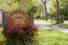
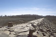
The Phoenix Bike Trail (download Phoenix Bike trail map) offers 4.5 miles of flat, paved access to Fairhaven's forests, salt marshes, and neighborhoods. From the Phoenix Bike Trail, you can explore Little Bay via the Little Bay Extension and connect into the Mattapoisett Rail Trail. You can find more information about the Phoenix Bike Trail from Buzzards Bay Coalition. Photo by Chris Richard
Pope Beach
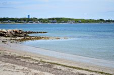
Pope Beach, one of Fairhaven's public beaches, offers scenic views of Priests Cove and a place to relax and enjoy the sun. There is some parking available at the end of Manhattan Avenue. You can find more information about Pope Beach from Buzzards Bay Coalition.
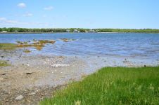
Seaview Avenue Beach and Boat Ramp
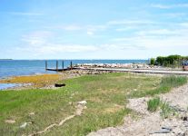
The Seaview Avenue Beach and Boat Ramp provides paddlers, boaters, and beachgoers access to Nasketucket Bay. From here, you can enjoy the scenic views of the Nasketucket Bay State Reservation across the water. The boat ramp accomodates boats up to 50 feet and small boat owners can keep their vessels at the dinghy storage area for a small fee. You can find more information on Seaview Avenue from Buzzards Bay Coalition or contact the Fairhaven Harbormaster (harbormaster@fairhaven-ma.gov, (508) 979-4023 ext 124).
Shaw Farm Trail
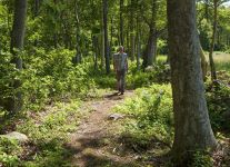
The Shaw Farm Trail (download Shaw Farm trail map), located off of the Phoenix Bike Trail/Mattapoisett Rail Trail just east of Shaw Road in Fairhaven, provides an opportunity to explore coastal forests, farmland, and meadows. There is a bike rack at the trailhead, so you can stop to enjoy a walk through the woods. This trail also connects the bike path with the trails in the Nasketucket Bay State Reservation (download Nasketucket Bay State Reservation trail map), which will take you to Nasketucket Bay.
Because much of the Shaw Farm Trail passes through private property, please take care to stay on the trail and respect the land, private property, and other visitors during your visit. You can find more information on Shaw Farm from Buzzards Bay Coalition.
Fairhaven TV Hometown Hikes - Shaw Farm Trail for a look at what you might see on the trail!
Shipyard Farm
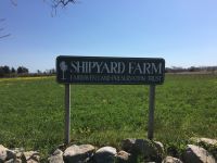
Explore the transition from farmland to salt marsh at Shipyard Farm. The trail begins on Sconticut Neck Road and heads east across farmland to the water, where you'll find Round Cove. The trail then heads north across a few small tidal creeks. Turn right as the first junction (marked with a double blaze) to wander through the woods. From there, the trail joins a wider road through the woods where you can either circle back and return to Shipyard Farm's field or turn right and cross Sconticut Neck Road to explore the neighboring Winsegansett Marshes. You can find more information on Shipyard Farm from Buzzards Bay Coalition.
West Island Improvement Association
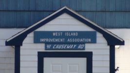 This three-acre site serves West Island residents. It provides a clubhouse and an athletic field. The WIIA maintains its principal office at 41 Causeway Road on the Island. The purpose of the WIIA is to promote the improvement and welfare of West Island; to maintain an organization for civic, educational, social, and recreational activities; to provide therefore a meeting place; and to assist in every way possible in the realization of these objectives. Photo by ML Baron
West Island State Reservation
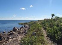
West Island State Reservation (download West Island State Reservation trail map) offers trails throughout to explore salt marshes, woods, and shoreline. The trails are unmarked, so bringing a map and compass is recommended. The main trailhead can be found on Fir Street just north of Causeway Road. You can find more information on West Island State Reservation from Buzzards Bay Coalition.
Fairhaven TV Hometown Hikes - West Island State Reservation for a look at what you might see on the trail!
West Island Town Beach
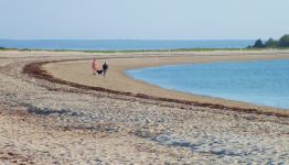
West Island Town Beach is a great place for the whole family. From the beach, you can see Buzzards Bay, the Elizabeth Islands, and the salt marshes of the West Island State Reservation. Lifeguards are present from June through August and the beach is great for dog walks in the off-season. The Town beach facility consists of an unpaved parking lot for approximately 100-150 cars that leads to a sandy beach. You do need a beach permit to park. There are no permanent restrooms at the site; however, seasonal portable restrooms are provided. You can find more information on West Island Town Beach from Buzzards Bay Coalition. Photo by Eric Birkeland
Winsegansett Marshes
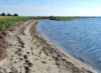
Winsegansett Marshes offer a well-marked trail starting from Sconticut Neck Road. The mail trail to Winsegansett Pond begins from the southern trailhead on Sconticut Neck Road. This path has boardwalks through the wettest parts of the marsh. When you see signs marked "Winsegansett Pond," turn left off the mail trail to enjoy the view.
If you continue along the trail past the pond, you will reach a crushed shell driveway. This portion of the trail crosses private property, so take care to follow the green markings to stay on the trail. Continue straight to reach the sandy barrier beach, which you can walk along to the left until you reach the inlet of Winsegansett Pond. You can find more information on Winsegansett Marshes from Buzzards Bay Coalition.
For other places to visit around town, the Fairhaven Office of Tourism is a great resource.