New Harbor Superfund Site and Virtual Meeting Information

1. Site-wide subtidal Superfund dredging is now complete!
After more than 17 years of effort, the Superfund dredging of PCB-contaminated sediments in both the upper and lower harbor below the low tide line was finally completed in March 2020. In total about one million cubic yards of PCB-contaminated sediment has been removed. As a result, EPA’s rail-accessible sediment dewatering and load-out facility on Hervey Tichon Avenue is being decommissioned and transferred to the City of New Bedford for commercial/industrial reuse as part of the working waterfront.
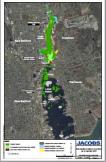
The MAP shows all the subtidal areas that were dredged as part of the Superfund cleanup over the years (dark green areas). This map also shows those shoreline areas that have been remediated to date (light blue areas).
2. Cleanup now focuses on shoreline/saltmarsh remediation and restoration in the upper harbor
Moving forward, now that the subtidal Superfund dredging is complete, remediation will focus on those shoreline/saltmarsh areas in the upper harbor north of Route 195 that have not yet been remediated. Note that in 2020, the two northern-most shoreline zones immediately south of the Wood/Slocum Street bridge (East Zone 1 and West Zone 1) were remediated. All removed contaminated soil/sediment was thickened using Portland cement and then disposed off-site at a licensed PCB landfill. The excavated shoreline areas were then backfilled with clean topsoil and planted with thousands of native salt marsh grasses, trees and shrubs. Additional saltmarsh planting at these two areas will occur in spring 2021 to take advantage of the best time of year for saltmarsh grass planting. Air monitoring occurs throughout this type of work to ensure it is being performed safely.
This year (2021) EPA and the Army Corps of Engineers plan to remediate East Zones 4 and 5 (south of Pleasant Street in Fairhaven) and West Zones 4 and 5 (south of Belleville Road in New Bedford). These areas are shown in yellow on the attached map. The same procedures will be used as noted above: All removed soil/sediment will be thickened with Portland cement at EPA’s Sawyer Street facility and then disposed off-site at a licensed PCB landfill. The excavated shoreline areas will be backfilled with clean topsoil and planted with thousands of native salt marsh grasses, trees and shrubs.
3. Reminder: fish and seafood caught in and around the harbor remain contaminated with PCBs
Even though the subtidal Superfund dredging is complete, fish and seafood caught in and around the harbor will remain contaminated with PCBs for some time. Local fishermen/women should familiarize themselves with applicable fishing restrictions and advisories to ensure harvested seafood is safe to eat. See epa.gov/superfund/newbedford for more details, or contact myself, ZaNetta Purnell, EPA’s Community Involvement Coordinator, at 617 918 1306 or at purnell.zanetta@epa.gov.
4. Virtual Public Meeting to be held January 13, 2021 at 6:00 pm
EPA will hold a virtual public meeting on January 13th at 6pm to discuss the status of the harbor cleanup including remedial work planned for 2021. This meeting will be held on the Microsoft Teams platform, and further sign-in instructions will be distributed via email in the near future and will also be posted at: epa.gov/superfund/newbedford under ‘Stay Updated’ and ‘What’s New’. Please feel free to reach out to me with any questions, special needs or assistance you may need when joining this meeting.